No geography needed
The map moves for you
Guided journeys fly from place to place and tell the story, one stop at a time. Three are open today: the road to Bethlehem, the Temple with Simeon and Anna, and the Magi and the flight to Egypt.
 TERRA VERBI
For families and solo readers
A 3D map of the land in the time of Jesus: more than fifty towns, the roads between them, and chapter and verse where the stories happened.
7 days free, the whole map · Cancel anytime
Names on a page
Luke 10:30 About 3,300 feet, in 15 miles. Terra Verbi shows you, in 3D.
And they went into Capernaum.Where is it, and what was there?Mark 1:21
He went before, ascending up to Jerusalem.Why “up”?Luke 19:28
What’s inside
Here the same land has hills, roads and streets. Every clip on this page is the real map, recorded live in a browser. There is nothing to install.
Guided journeys fly from place to place and tell the story, one stop at a time. Three are open today: the road to Bethlehem, the Temple with Simeon and Anna, and the Magi and the flight to Egypt.
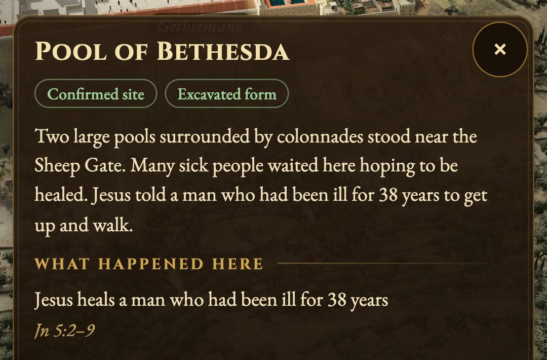
More than forty places open with what happened there and the reference, so you can turn to it in your own Bible.
Turn, climb and come down close. Capernaum, Jericho, Jerusalem and more than fifty towns stand in their places, on one connected map.
Start your 7 free days7 days free, the whole map · Cancel anytime
How we build it
Distances between towns are true. Heights are stretched, so the hills are easy to see. Towns are reconstructed from historical and archaeological sources, such as Josephus, the Mishnah and excavation reports.
A second label says whether the shape you see is excavated, reconstructed or hypothetical. Terra Verbi is new, so the labels are there for you to check, and the first 7 days are free.


“Our feet shall stand within thy gates, O Jerusalem.”
Psalm 122:2
Who it’s for
Read a Bible story together, then go and see the place. Screen time that leads back to the page: no points to score, no ads, just the place and the verse.
Keep the map open beside your reading plan. Distances you can check, chapter and verse. A serious atlas, not a children’s game.
Teaching a class? Try it yourself first, on your own screen. For a class or a church, write to contato@terraverbi.com and we’ll set up a pilot.
A few minutes a night
You don’t need to know the geography to lead it. Ten minutes is enough.
Membership
What you get
Your 7 free days
About $9 a month. Three monthly payments would be $45.
Start your 7 free daysMonth to month, for the most flexibility.
Start your 7 free daysAlready a member? Sign in.

Seven days is enough to fly the whole land and take every journey. If it is not for you, cancel before day 8 and you pay nothing.
Best on a computer or tablet. Nothing to install: it runs in your browser.
Secure checkout by Stripe. We never see your card number. Questions? Write to contato@terraverbi.com.
Questions
Pick a plan and add a card. For 7 days the whole map is yours to explore, and you pay nothing. We email you before the trial ends. If you cancel before day 8, you are not charged; otherwise your plan starts. To cancel, open your account page and choose “Manage billing”.
Yes, it opens on phones. The map is heavier there, so it takes longer to load. For the best experience, use a computer or tablet with a modern browser. There is nothing to install.
A study Bible shows the land flat, from above. Here you can turn it, come down to the streets and see how far and how steep each road was. And each place opens with its verse.
No. Terrain comes from real elevation data, and towns are reconstructed from historical and archaeological sources. Where something is uncertain, the map says so with a label.
No. The guided journeys move the map for you and tell the story one stop at a time. You only need to read along.
It moves at the pace of reading, not of a game: no points, no levels, no ads. A few minutes around a passage, then close the map and let the children tell it back.
Terrain comes from real elevation data, and towns are placed and reconstructed from archaeology and historical sources. Where scholars disagree or details are unknown, we make a careful reconstruction, mark it as such, and keep refining it.
The map keeps growing. New towns and journeys are included as they are ready, so you don’t pay again for them.
It is made to be explored together, with a parent at the controls for little ones. Older children, teens and adults can explore on their own.
Neither, and everyone is welcome. We show places, roads and Scripture references, and leave interpretation to your family and your church. Short quotations come from public-domain translations, always with chapter and verse, so you can read them in your own Bible.
A household membership covers you and the people who live with you, on your own devices, with one sign-in. Classrooms, co-ops and churches need a group license, which is coming soon. Write to contato@terraverbi.com and we’ll set up a pilot.
Still unsure? That is what the 7 free days are for.
P.S. You get 7 full days with the whole map. Add a card today, cancel before day 8 and you pay nothing.